 Award
Award
Programmes Award
Winner
Urban Active Modes Plan by Far North District Council
In brief
Whilst the Far North District is largely rural, there are a dozen key urban areas where people could use active transport for many daily needs. These towns are generally compact, so the distance between destinations is suitable for walking. The urban active modes district-wide plan focuses on improving footpaths and crossings in the district.
The Far North District-wide Urban Active modes plan is possibly the first time anyone has accurately quantified the scale of work needed on footpaths to get them up to a minimum standard.
The appropriate crossing type and recommended footpath coverage on every street in fourteen FNDC towns was produced.
 The details
Whilst the Far North District is largely rural, there are about a dozen key urban areas where people could use active transport for many daily needs. These towns are generally compact, so the distance between destinations is suitable for walking.
Providing transport choices for people to walk, scoot or bike improves public health, accessibility, social equity, liveability / vibrancy of neighbourhoods, and the environment. It is especially important for rangatahi/children/teenagers, kaumātua/older adults, people with disabilities and others who cannot drive. It is also key to meeting the Far North District’s zero carbon goal for all communities by 2050.
The built environment and taiao (natural environment) affects our collective wellbeing, community health and equity. There is tremendous opportunity to improve public health outcomes for our tāngata (people) by providing choices for people to walk, wheel and cycle for their everyday transport.
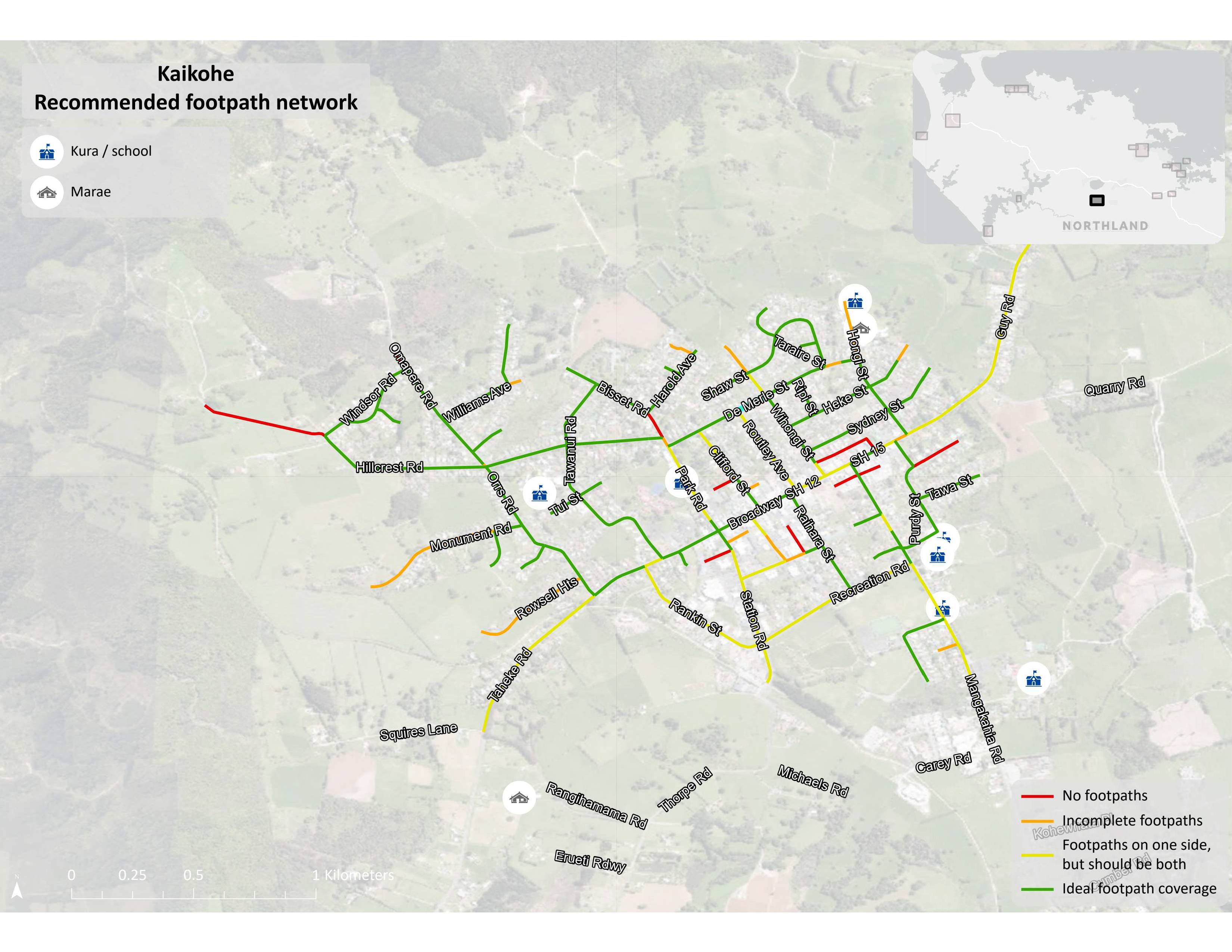
This Urban Active Modes Plan analysed the current and recommended levels of service to inform walking network investment decisions across the rohe (district). Maps of each town showed prioritised streets for new crossings and footpaths. Image right - shows recommended footpaths for Kaitoke.
Public engagement undertaken included an online survey answered by 228 people from most of the towns. The map-based engagement included 126 comment pins, with many of these located in urban areas. The most significant barriers included “no paths or safe cycleways where I want to go”, “speed of cars”, and “path surfaces in poor condition.”
Success to date. The project was completed in November 2023 and is now in the phase of moving from a high-level plan into confirmation of funding/implementation. Investment scenarios for the level of annual funding (capital works, low cost / low risk improvements and footpath renewals) required to meet various levels of service were provided. Moving from the district-wide plan to implementation requires local knowledge and further local decision making to confirm these priorities.
 Coverage
This urban active modes plan covered the entire Far North District Council District including:
• Ahipara (Ahiparapara),
• Doubtless Bay (Mangōnui-Coopers Beach-Cable Bay-Taipā),
• Kaitāia,
• Kaikohe (Kaikohekohe),
• Opononi / Ōmāpere,
• Rawene,
• Kawakawa,
• Moerewa,
• Kerikeri,
• Opua,
• Haruru,
• Paihia,
• Russell (Kororāreka),
• Waipapa.
Potential applicability. Other road controlling authorities can apply similar methods of prioritisation of pedestrian footpaths and crossings, comparing them to the ideal (or minimum) standards.
Relative uniqueness and innovation
Footpaths: This project is possibly the first time anyone has accurately quantified the scale of work needed on footpaths to get them up to a minimum standard.
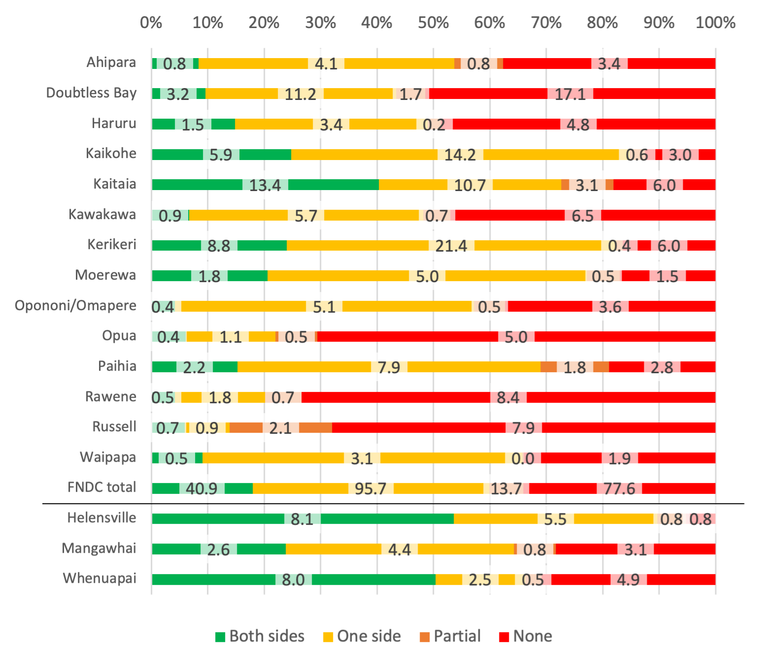
Footpath network coverage in each of the FNDC towns as a percentage of the total urban street length of each town is shown in the following graph. The distance (in kilometres) of coverage in each town are added as data labels. Three towns of comparable populations (with better level of service of footpaths) are also shown as benchmarks. See graph below.
The methodology for prioritisation of footpaths included data such as motorist operating speeds and vehicle volumes data from Waka Kotahi’s Megamaps. As well as this, footpath condition reports from Far North District Council’s asset management software RAMM was used.
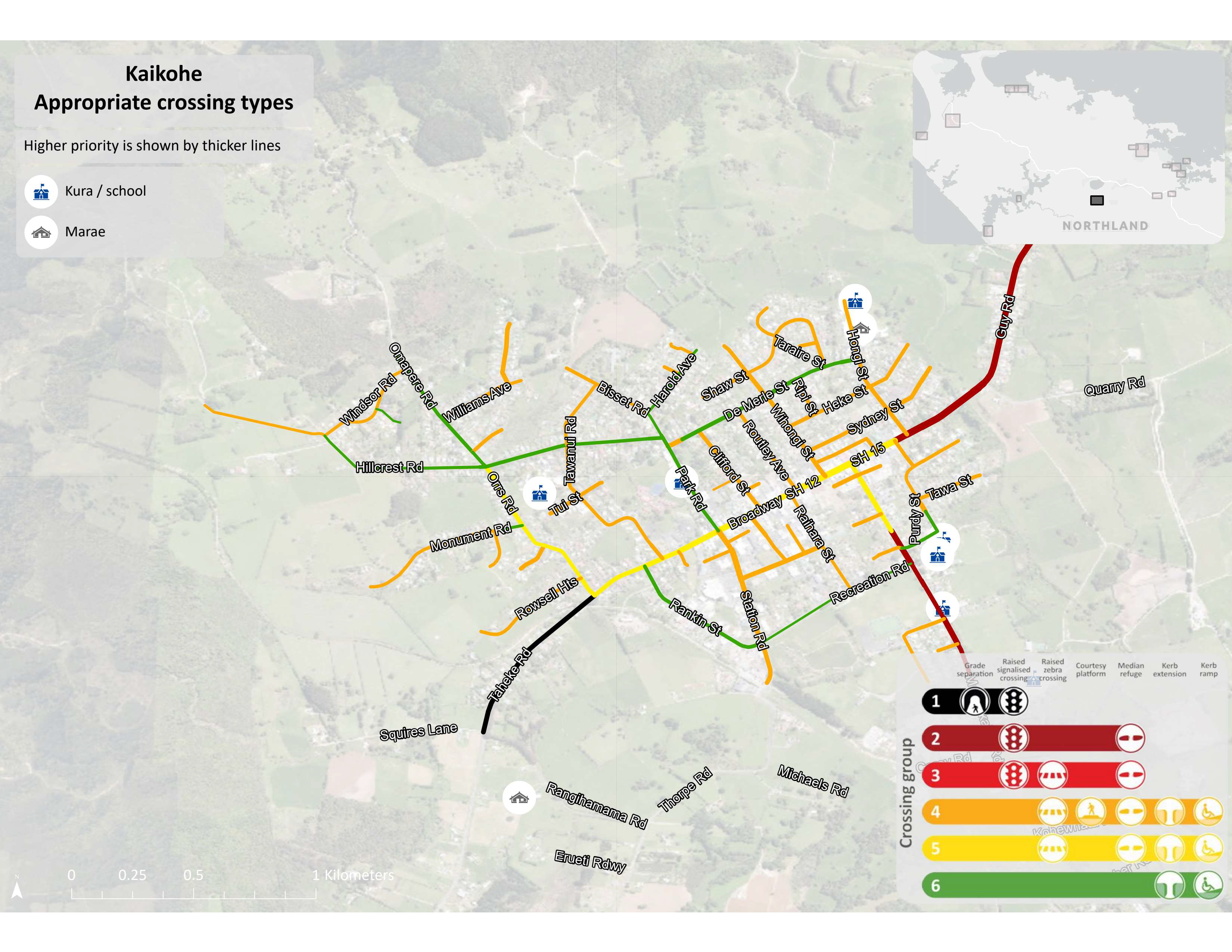
Crossings: The provision of crossings was also quantified and benchmarked against the minimum standard, as per Waka Kotahi NZTA’s Pedestrian Network Guidance (PNG). In particular, the crossing prioritisation used the PNG crossing selection flowchart.
Posted speed limits, traffic volumes and road stereotype/lane count were some of the variables used in the crossing selection flow chart.